The idea is that a GPX file would contain Route Points defining the path you wanted to follow. Waypoints that define things of interest along the way, and numerous Track Points following curves and bends of the roads, so the display on the GPS follows the map rather than showing a series of straight lines connecting the Route Points.
All clear and straightforward. Sort of …
GPX Extensions
In almost all route planning software, we can define our route using two types of Route Points: Shaping Points and Via Points.
These are still Route Points as defined in the GPX standard, but they are given slightly different characteristics using the Garmin GPX extensions.
Via Points are hard markers on the route through which we have decided we must pass. Typically, there are only two Via points in a route, the start and the finish, but nothing stops you from defining more. Lunch and fuel stops are typically Via Points I use on routes.
Shaping Points are a softer version of Route Points and allow the GPS to skip over them if you are going away from them or have passed close to them. Without Shaping Points to highlight the roads I’d like to ride, the route planning software will pick the roads it thinks are best.
Another difference on my Garmin Zumo XT is that Via Points are announced, whereas Shaping Points are not. It might sound like nothing, but it matters when the Zumo XT announces you are approaching and then at the Via Point in excruciating detail, including the postcode and the country I’m in.
And this gives us the first difference between planned routes and GPS instructions.
In the GPX files MyRouteApp produces, the Garmin-defined extensions are in use. Of course, nothing stops a TomTom GPS from using the same extensions, and most do, but that doesn’t mean that a TomTom GPS will treat them the same.
One of the early phone-based GPS’ I used would require me to pass within 50 meters of a Shaping Point, or it would start insisting I turn around and navigate back to the missed point.
Track Points
The original use for Track Points was as breadcrumbs, a trail of where we had been rather than where we wanted to go.
Their original use has morphed slightly, and route planning software now uses Track Points to describe the twists and turns in the road.
If you upload a GPX to your GPS that doesn’t have Track Points, the usual giveaway is that the route appears on the GPS as straight lines on the map rather than following the roads.
You can fix that problem either on the GPS with an option like “Convert to Route” or change how the route planning software produces the GPX file.
I planned a route using MyRouteApp with only two Via Points, Lincoln and Moffatt, in Scotland. When I exported the GPX file, it contained 8,398 Track Points, an average of 38 Track Points per mile, or one every 47 yards (42 meters).
With that number of markers on the route, you would think it was difficult for the GPS to do anything but follow the prescribed path.
Not quite …
Check The Map
Each of the map overlays used by route planning software is subtly different. For example, Open Street Map, the one you see on our FREE touring route pages, differs from TomTom maps, and neither of those is the same as Garmin’s Here maps.
I find the presentation of TomTom maps in MyRouteApp the easiest to work with when planning a route. There is no advantage; I just prefer the map layout.
Whether I’m using a TomTom, Garmin or a phone-based GPS, it pays to check that the route I’ve planned appears the same on all of the maps MyRouteApp has available.
The same route, with the same Shaping and Via Points, will often change as I cycle through the maps. Not knowing the ins and outs of how the route planning software makes its choices, I can’t tell you why this happens.
Perhaps the data for one of the maps has a road defined as a super smooth B-road, and another map classes it as my proverbial goat track.
The route always follows the same Via and Shaping points, but the roads chosen to link these up – the Track Points – may differ, which gives us the second major reason for GPS magical mystery tours.
GPS Settings
The third reason for a magical mystery tour, and how I ended up on the M6 Toll Road while my colleague rode the route as planned on the A5, is due to differences in the preferences set on the GPS and those selected for the route planning software.
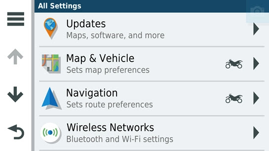 Although I’d planned to use the A5, and the GPX file contained numerous Track Points, there was a gap between the Shaping Points, large enough to allow the Garmin XT to plot a route on the M6 Toll road, as it considered this to be the best route.
The Garmin GPS appears to consider the Track Points from the route planning software as a suggestion, not a hard and fast requirement and will create its own Track Points.
It was a simple error on my part. I’d not set the Garmin to avoid Motorways, and despite all of the detailed route planning, the Garmin decided it knew best and took me onto the M6 Toll Road.
After I’d paid £4 to travel just one junction, the Garmin turned me back onto the A5.
It was my fault for not having Avoid Motorways set and for not using enough Shaping Points to remove any doubt about my desired route.
Bottom Line
There isn’t a right way or a wrong way to plan routes so that we remove the magical mystery tours GPS navigation can take us on.
Nonetheless, we can minimise our GPS’ opportunity to make random decisions.
Ensure the GPX files produced by the route planning software are compatible with the GPS. The route shown should follow the roads, not be a succession of straight lines.
Check the planned routes on as many map types as possible and add Shaping Points until all maps show the same route.
Check that the GPS preferences are the same as the route planning preferences.
Hopefully, that helps. Summer is coming, and our magical – if annoying at times – boxes of electronics will soon guide us on all sorts of adventures.
And remember: If it all goes according to plan, it wouldn’t be much of an adventure.
And Thank You
My thanks to Nick Carthew from the UK Riders My-Route-App group on Facebook, who noticed that I’d switched the meaning of Via and Shaping points around in my head when writing the original version of this article. The one you have just read has been corrected.
Thanks, Nick.