As this is a detailed review of Kurviger, a route planning and mobile phone navigation application, I’ve split it into two pieces.
In this article, I’m looking at the web-based route planning software and highlighting where Kurviger brings something unique to motorcycle route planning.
I’ll cover the mobile phone navigation app and the Android Auto integration in a later article. Enjoy …
All-In-One Navigation
One of the primary advantages of using a mobile phone for navigation over a dedicated GPS unit is the synergy between the application used for route planning and the one used for navigation.
Using the same system for both eliminates the interpretation of the route. I found how irritating this can be while touring the Sauerland in Germany. Which is somewhat ironic, considering the lengths we go to make our free touring routes compatible with as many devices as possible.
I’d planned a route around the town of Hamm and loaded this onto my Garmin XT. When Garmin processed the list of Waypoints in the GPX file, it generated a different route that took me through the residential area.
Just my luck that the schools had just finished for the day, and the traffic was a little manic.
Self-Contained
The two most well-known all-in-one, self-contained planning and navigation applications are Calimoto and MyRouteApp.
I have a lifetime license for the MyRouteApp planning software and the navigation app. Although I’ve looked at Calimoto, I haven’t found anything to choose between the two.
And then I came across Kurviger …
Kurviger
The group of motorcycle-friendly hotels in the Sauerland have put together a selection of routes for visitors, and a few are available on Kurviger.
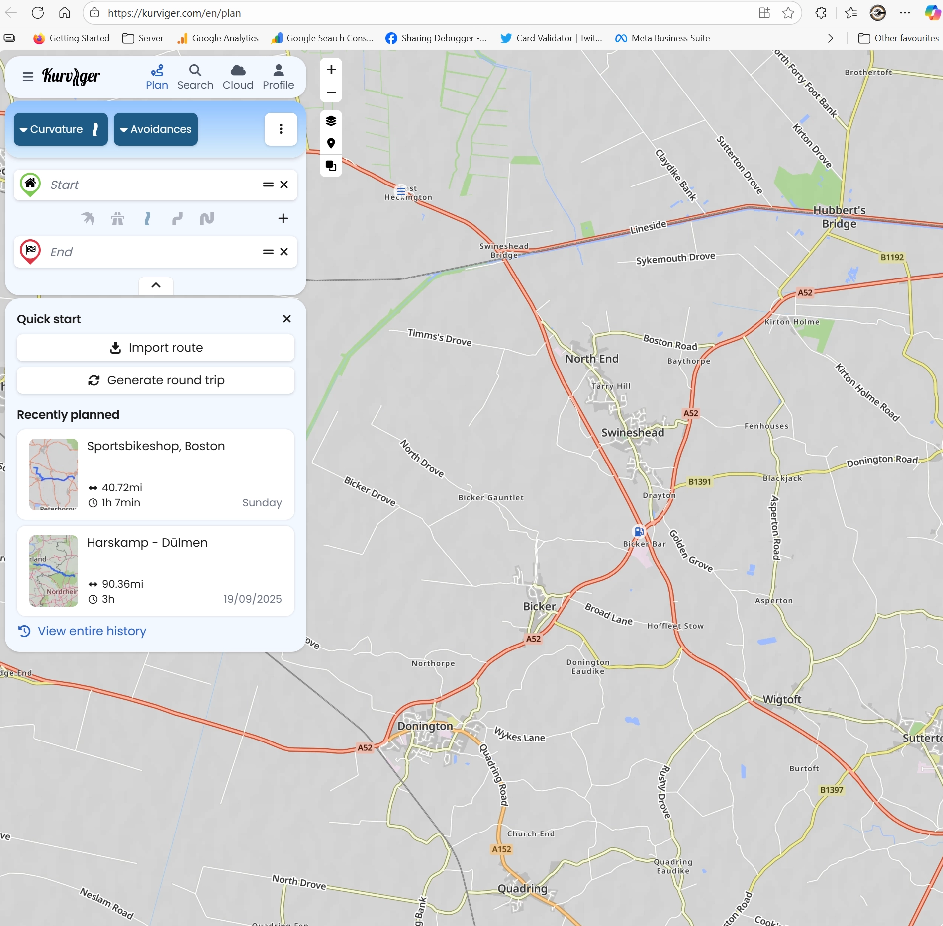
At first glance, it appeared to be the same as the other planning and navigation offerings, but digging a little deeper shows that Kurviger have thought about the needs of the touring motorcyclist.
Planning With Kurviger
As you would expect, Kurviger does all of the traditional things. You can upload an existing route – plan a round trip of a chosen length and in a general direction – and select the type of roads you want to ride.
The interface is crisp and clean, and doesn’t take long to learn, all of which are table stakes for a navigation app.
Where Kurviger brings something extra is when you start planning specific routes.
The process begins with setting the start and end points. You can place a start point anywhere you like, and when you begin navigating, Kurviger will ask you for your preference in getting to the start – Fast, Curvy, Twisty, etc. But I’ll cover that in detail in the next article.
I chose a starting point at EuroPoort (Rotterdam) and an endpoint at the Landgasthof Zum Burghoff in the town of Dreislar, near Medebach, Germany. There is support for using postcodes, with the OpenRouteServices postcode look-up giving the best results.

As you can see from the screenshot, everything is standard at this point. Kurviger has planned the route along the autobahns and then turned south into the Sauerland National Park. But what if I want something different?
Different Roads
The only way to get out of Rotterdam – for me anyway – is on the autobahn/motorway. The roads don’t get interesting until I’m east of Arnhem, so I may as well get there as quickly as possible, and this is where Kurviger is different.
Just after Arnhem, I’ve added three waypoints (shaping points) to the route, and then I’ve told Kurviger the type of roads I’d like to ride between these waypoints.
- Europoort to Waypoint 1 – Motorways please. Just get me there
- Waypoint 1 to Waypoint 2 – Use my default setting of fast and curvy
- Waypoint 2 to Waypoint 3 – Let’s up the twistiness and slide between Munster and Hamm
- Waypoint 3 to the Hotel – Back to fast and curvy roads.
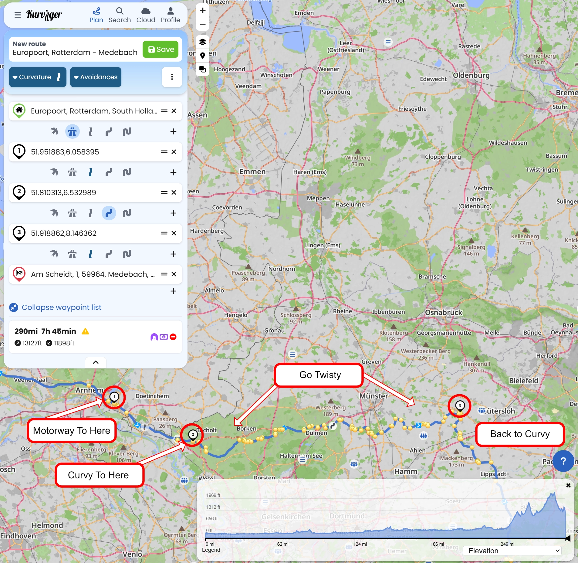
Each of the yellow dots represents a Kurviger-generated turn point, which also shows the turn-by-turn navigation instructions, ensuring Kurviger’s navigation app stays on track.
The algorithms in the Kurviger Tourer+ phone navigation app are identical to those in the desktop planning software, resulting in a high correlation between planned and actual routes.
Avoidances
Having told Kurviger the type of roads you wish to ride, you can further refine the route by setting road types and how much you want to avoid them.
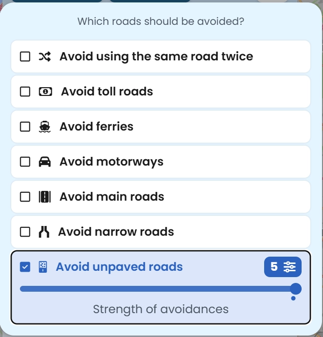 Rather than being set for specific sections of the route, these are established as overall requirements.
I have no off-road skills (other than crashing), so my preference, no matter how twisty I want the ride, is to avoid unpaved roads.
This doesn’t mean Kurviger won’t take me on an unmade road; perhaps it is the only option, but Kurviger will do what it can to avoid them.
For each of the avoidance options, I can turn my desire to avoid them up or down. One is that I’m okay with these roads, whereas five is only pick them if there is no other way.
Coffee Stops
Having got the route as I want it, I’m not going to ride it all in one go. Clicking on the map icon for waypoint two, the information bar shows me that it is 121 miles from the start in Europoort; I’ve got another 169 miles to go, and in the Interesting Places Nearby, Daddy’s Bikertreff is shown (popular biker café). The default language is German, but you can right-click and select ‘Translate’ from the options to view it in your preferred language.
There is also the option to add the selected place to the route. It is a neat option and much simpler than scanning the map looking for a café in a list of POIs.
Petrol & Distance
Finding a petrol station while planning isn’t quite as straightforward, but it’s still easy enough. Zoom in on the map and the petrol stations appear as icons. Click on the icon, and the option to add it to the route appears.
Alternatively, with your planned route saved and displayed, click on the Search icon in the top menu bar, and just below, where it says “Location or Coordinates”, enter any of the following terms:
Kurviger will then search along your planned route and show you the petrol stations, cafes, etc., whatever you have searched for, along or close to your route.
Just ensure that you are only displaying the part of your route that you want to search. If you zoom out, Kurviger thinks this is the search area and might suggest a cafe 200 miles away.
Keep the zoom tight to your route, and this option works well.
Improvements
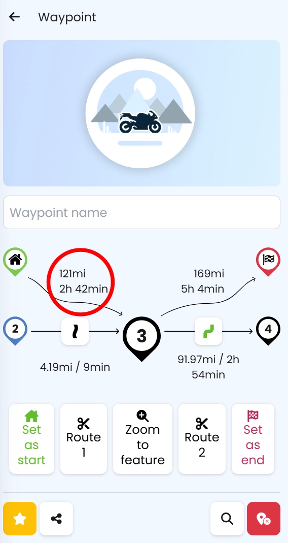 One area where Kurviger could perhaps improve is in the distance between points. In the waypoint view, an overall distance is provided, but no other references to distance or time are given.
My NT1100 has a comfortable 220-mile range, plus some spare, and I typically need a fluid change (some in, some out) a bit before then.
Where on the route, 160 miles or two hours of continuous riding might be, isn’t shown. I had to add a waypoint, then click on it to see the distance and estimated time from the start.
It isn’t a big issue, but with so many slick planning features, it stands out as a notable omission.
And Finally
There is, of course, a big green SAVE button, which is where the Cloud symbol comes in.
Routes are saved in your private directory, which you can organise into subdirectories to make them easier to find in the future.
If you choose Kurviger Tourer Plus, you can use the Kurviger mobile phone navigation app. Alternatively, if you only want the planning software (website), it is free, but you won’t have access to all the advanced planning options.
A detailed review of using Kurviger for navigation on a mobile phone and via Android Auto is coming, but for now, I thought I’d see what happened if I exported the route as a GPX file.
Export
The option to export routes isn’t limited to GPX. You can select Google (KML), TomTom (ITN) and iGO8 (KML) formats. GPX is available in two variants: standard and advanced.
If you are a Garmin user, the advanced format is the one you want, along with the option to “Embed Garmin route points”.
Selecting this option creates a GPX file that attempts to prevent Garmin GPS devices from making random route decisions, but it comes at a cost. The conversion of the route when uploaded to your Garmin will take longer as there are many more waypoints to process.
The file size for an embedded Garmin route point file is roughly 40% bigger than a standard GPX file.
It is also highly recommended that you turn off Garmin’s automatic recalculation, as Garmin devices appear to recalculate the entire route if this option is enabled, even if you are only a few meters from your destination when you stray off course.
Add More Waypoints
On our free touring routes, we manually add as many waypoints as we hope will keep you on track. Kurvier has an option to automatically add more waypoints either “intelligently” or at 4km intervals.
When exporting the route, enable these options, and Kurvier will place enough waypoints for even the most psychotic GPS to follow.
You can see an example of how this helps ensure a GPS sticks to the planned route below, when I uploaded the GPX to MyRouteApp.
Import
Having imported the route into MyRouteApp, you can see the difference between using the navigation app that comes with the planning software and an external GPS.
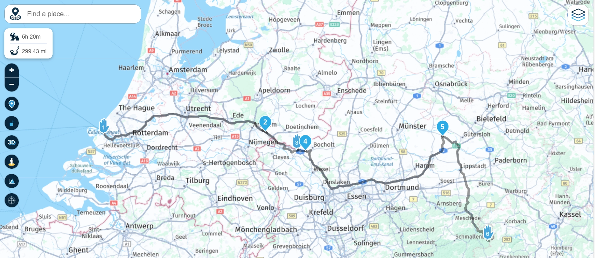
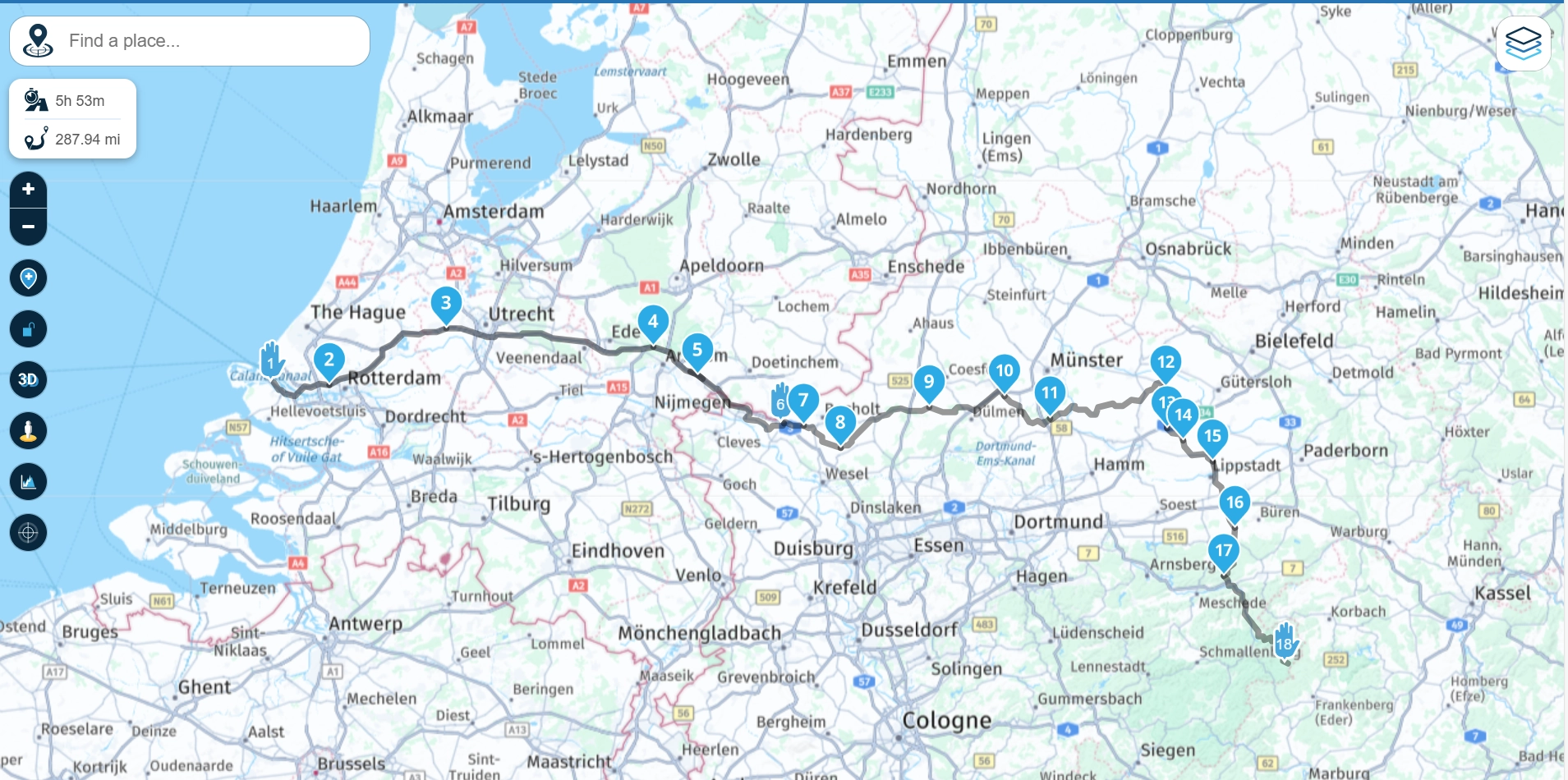
The two routes, as standard, differ significantly. Kurviger is 290 miles, and the same route loaded into MyRouteApp is 300. MyRouteApp has also taken me closer to the industrial sprawl of Dortmund and south of Hamm.
There is nothing wrong with the MyRouteApp interpretation. It has plotted an effective route between the waypoints, using the preferences set. The extra features of Kurviger have been lost, as they would be when uploaded to a standalone GPS.
Enabling Kurviger Intelligent Waypoints when you export your route helps resolve the issue.
Bottom Line
Kurviger is intuitive, slick, quick and easy to learn. So, how much does all this cost?
There are three levels of membership: Free, Tourer and Tourer Plus. Tourer Plus is the one you want, and at 30 euros, or roughly £25 a year, why bother with the other two?
All of which leaves me with the task of finding somewhere else to go, and using Kurviger to plan and navigate my way there. Only so I can verify my facts for the follow-up article, obviously.
I wouldn’t just be going for a ride … Honest.