



Motorcycle Tour Planning is a bittersweet experience.
On the one hand, I’m inside, sitting in front of a computer rather than riding a motorcycle. This makes me unhappy. I’d rather ride the bike, even if it means having to clean it afterwards.
The sweetness comes from route planning and discovering roads that – I hope – will be as entertaining in real life as they look on my computer screen.
The first week-long tour is scheduled for May ’23, which, as I write this, is 118 days away. There will be numerous motorcycling activities before then, but the first multiday trip is a return to the Harz National Park. It was that good.
Uploads
There must be a dozen or more different software apps for planning motorcycle tours. BaseCamp is popular, although I’m never sure why. I’ve tried it a few times and always found it irksome. But perhaps that is due to not battling through the learning curve.
BaseCamp was once synonymous with Garmin GPS units and how you uploaded routes. Now I download the route to my phone, and Garmin Drive automatically opens and asks if I wish to send the route to my Garmin XT.
It has become so simple that I’m shocked when it doesn’t work the first time, rather than in my BaseCamp days when I was amazed when it did work.
Uploading a route, though, is the last part of the motorcycle tour planning puzzle. First, you need a route, and even that has become so much simpler than it once was.
Planning
If my time on the bike is to be reduced, then I’ll feed my motorcycling obsession any way I can. An hour or three plotting and scheming with the MRA Route Planner is one way of satisfying my obsession with motorcycles.
 There are other motorcycle tour planning apps available, ViaMichelin.com, for example. It is advert laden, but then again, it is free, so it’s hard to complain. However, I could never find a way of exporting the routes it planned as GPX files which I guess is missing for a reason.
The ViaMichelin Android and iPhone app, which connects to the website of the same name, is how you get navigation instructions.
It provides information on speed cameras, petrol stations, restaurants, and more. You just have to take a moment to look at the adverts that are paying for it all.
TomTom MyDrive is another contender for route planning. MyDrive has an obvious tie-up with the TomTom series of SatNav units, but the website is too slow to make planning an enjoyable activity.
 As I write this, there is an announcement on the MyDrive site saying that a new version of the site is coming. Perhaps that will address some of the performance issues.
But perhaps the definitive free route planning software is Google Maps, which is perfect if you don’t want a GPX route. Then again, why would you if you are using your phone for navigation?
And then, there are the navigation apps that will plot a route for you. Tell the app where you want to go and the type of ride you are looking for, and let the program do the planning for you.
If there is one advantage to automatic route planning, it is that no one is to blame if the route doesn’t match expectations. However, as I’m always excited by the prospect of a tour, leaving the route planning to the machinations of a computer isn’t something I’m overly convinced about.
Google Street View
No matter how you develop your routes, one of the big problems with tour planning is knowing what a road is like. On the screen, it can look epic, and when you get there, it is a twisting turning farm track.
I’ve planned a few shockers in the past. Roads that looked wonderful on the screen were OK on an adventure bike, but the sports bike riders were not the happiest of campers with my planning efforts. And this is where the wonders of Google Street View comes in.
German privacy rules prevent the use of Street View in most of the country, which doesn’t help when I’m trying to find that wonderful road with the double hairpin through the trees that I rode by chance last time I was there.
For the cross-country sections, getting to and from the Harz National Park, Street View is an excellent addition to route planning.
The Route
The easy way in and out of the Harz region is via the motorways, but where is the fun in that?
The closer I am to Rotterdam (Hoek of Holland) and the ferry, the more built up the area becomes. Utrecht, Amersfoort, Arnhem and Apeldoorn are all easily bypassed on the A4, A1 or A12 motorways, but I’m looking for the invigorating roads.
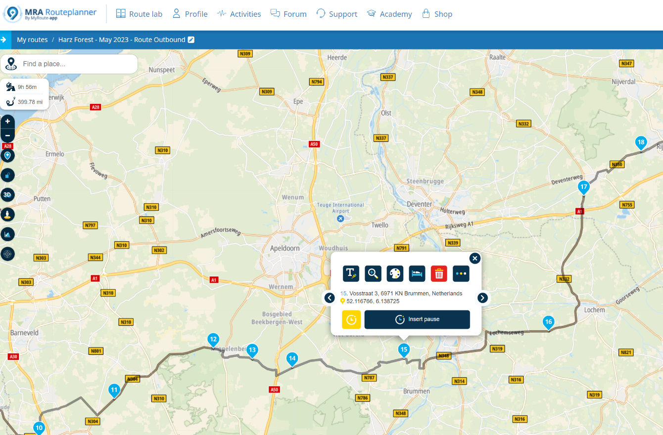
To bypass Apeldoorn and Arnhem, I’ll take the N304 and the N786 through the middle of them. “N” roads through the Netherlands are typically excellent, so I’ve no real worries picking them, but what about Vosstraat (waypoint 15)?
All of which leads me neatly to the bit that gets me so engrossed in motorcycle tour planning.
MRA Route Planner & Street View
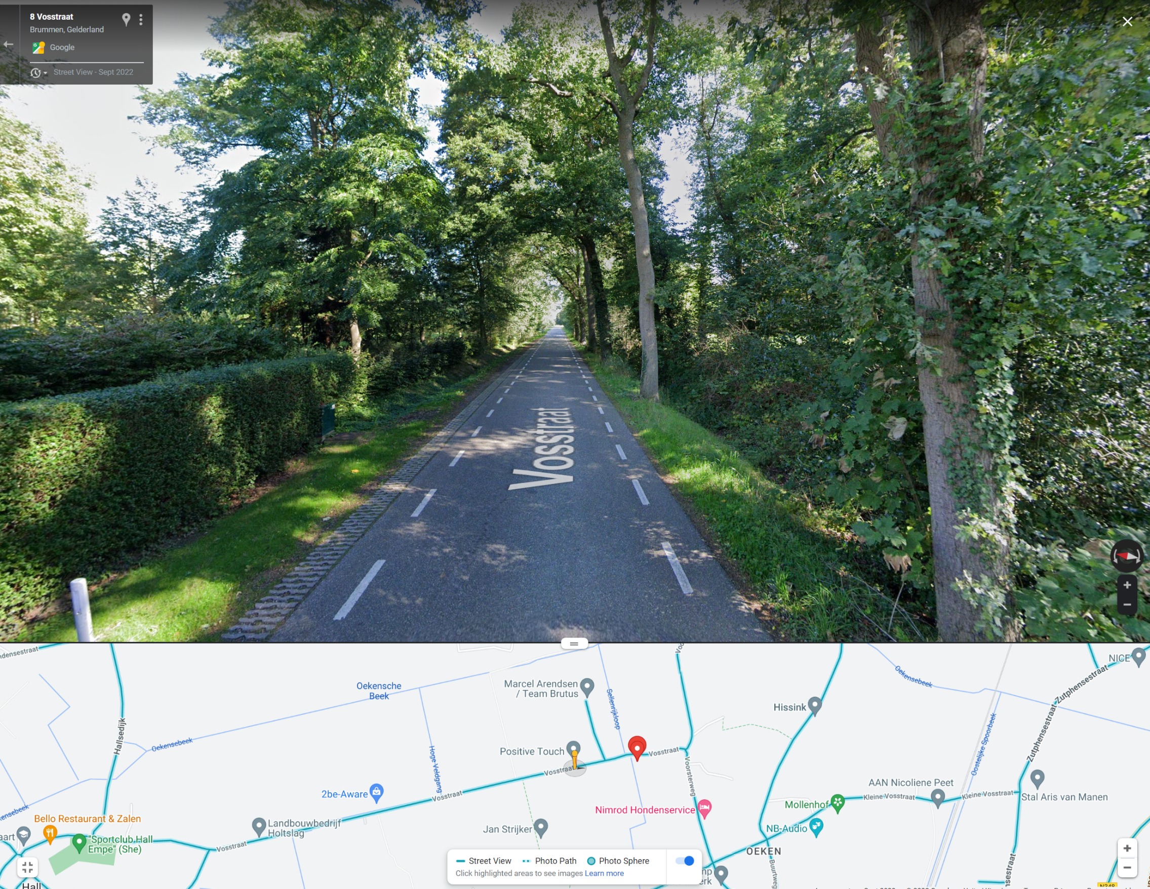
Clicking on the waypoint in MRA Route Planner brings up an information block. Highlighting and copying the latitude and longitude figures allows me to paste them into Google Maps and, from there, pick Street View.
And as if by magic, I’m on a backroad in the middle of the Netherlands, looking at a narrow tree-lined road with a good road surface that works for me as an alternative to the A1 motorway.
If only MRA (MyRouteApp, not the screen people) would build this feature in as a button on the information block, as they have a link to Booking.com.
Digging about in this way, I’ve found numerous oddball cafes and even a motorcycle clothing shop in the middle of the Welsh valleys. It takes time, but I typically end up so engrossed that I can whittle my way through a few hours without noticing.
Ultimately, riding the roads is the only way to know if they are as good as they look. But until then, it is an excellent way to feed my motorcycling obsession.
Clarity
We have no relationship with any of the products or websites we mentioned. I bought an annual subscription to the MRA Route Planner and the navigation app for a few years, upgrading to the Life Time license when it was last on offer.
The header image is based on an original work by Lara Jameson and is used here under license.















2 responses
On the left hand side of the map, 3rd button up from the bottom switches to streetview mode. All the roads with Streetview are highlighted in blue. Click anywhere on a blue Streetview road and the Streetview comes up. In the bottom lefthand corner is a overview map, drag this map around and click on any blue Streetview road and the view will change. Dead easy! There is no need for a waypoint or Lat/Lon coordinates.
My Route App includes native Streetview in the form of the familiar yellow stickman icon, which you’ll find in the Map Section. Not quite as convenient as the way you describe but at least it’s there.
See here for more information: [Link deleted]